Khanty-Mansi Autonomous Okrug
| Khanty-Mansi Autonomous Okrug — Yugra (English) Ханты-Мансийский автономный округ — Югра (Russian) |
|
|---|---|
.svg.png) Location of Khanty-Mansi Autonomous Okrug in Russia |
|
| Coat of Arms | Flag |
 Coat of arms of Khanty-Mansi Autonomous Okrug — Yugra |
 Flag of Khanty-Mansi Autonomous Okrug — Yugra |
| Anthem: | |
| Country | Russia |
| Administrative center | Khanty-Mansiysk |
| Established | December 10, 1930 |
| Political status Federal district Economic region |
Autonomous okrug Urals West Siberian |
| Code | 86 |
| Area - Rank within Russia |
534,800 km² 9th |
| Population ( 2002) - Rank within Russia - Density - Urban - Rural |
1,519,962 inhabitants 36th 2.8 inhab. / km² 91.5% 8.5% |
| Official language | Russian, Khanty, Mansi |
| Governor | Natalya Komarova |
| Vice-Governor | Viktor Krivyh |
| Legislative body | Okrug Duma |
| Charter | Charter of Khanty-Mansi Autonomous Okrug |
| Official website | http://www.admhmao.ru/ |
Khanty-Mansi Autonomous Okrug—Yugra (Russian: Ха́нты-Манси́йский автоно́мный о́круг — Югра́, Khanty-Mansiysky avtonomny okrug – Yugra), or Khantia-Mansia, is a federal subject of Russia (an autonomous okrug of Tyumen Oblast). The people native to the region are the Khanty and the Mansi, known collectively as Ob Ugric people. The general territory is historically known as Yugra.
The local languages, Khanty language and Mansi language enjoy special status in the autonomous okrug, while Russian remains the only official language.
The majority of the oil produced in Russia comes from Khantia-Mansia, giving the region great economic importance.
Contents |
History
The okrug was established on December 10, 1930, as Ostyak-Vogul National Okrug (Остя́ко-Вогу́льский национа́льный о́круг). In October 1940, it was renamed Khanty-Mansi National Okrug. In 1977, along with other national okrugs of the RSFSR, it became an autonomous okrug (Khanty-Mansi Autonomous Okrug). The administrative center is Khanty-Mansiysk. In 2003 the official name was added with word "Yugra" which represents ancient name of this land and its people.
Geography
Principal rivers in this region are Ob and its tributary Irtysh.
Khantia-Mansia is traversed by the northeasterly line of equal latitude and longitude.
Time zone
Khantia-Mansia is located in the Yekaterinburg Time Zone (YEKT/YEKST). UTC offset is +0500 (YEKT)/+0600 (YEKST).
Administrative divisions
| Number | Coat of arms |
District | Administrative center |
Map |
|---|---|---|---|---|
| 1 | Beloyarsky | Beloyarsky | 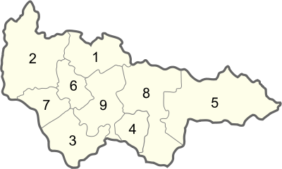 |
|
| 2 | Beryozovsky | Beryozovo | ||
| 3 | Khanty-Mansiysky | Khanty-Mansiysk | ||
| 4 | Kondinsky | Mezhdurechensky | ||
| 5 | Nefteyugansky | Nefteyugansk | ||
| 6 | Nizhnevartovsky | Nizhnevartovsk | ||
| 7 | Oktyabrsky | Oktyabrskoye | ||
| 8 | Sovetsky | Sovetsky | ||
| 9 | Surgutsky | Surgut |
Demographics
- Population: Khantia-Mansia has an area of 523,100 km², but the area is sparsely populated with a total population of 1,432,817 according to the 2002 Census. The administrative centre is Khanty-Mansiysk, with 53,953 inhabitants, but the largest cities are Surgut (285,027), Nizhnevartovsk (239,044), and Nefteyugansk (107,830).
- Ethnic groups: The indigenous population (Khanty, Mansi, Nenets) is only 2% of the total population. The exploitation of natural gas in Khantia-Mansia has attracted immigrants from all over the former Soviet Union. The 2002 Census counted twenty-five ethnic groups of more than two thousand persons each. The national composition:
| Population of Khanty-Mansi Autonomous Okrug[1] | ||||||||||||||||||||||||||||||||||
|
Historical population figures are shown below:
| census 1939 | census 1959 | census 1970 | census 1979 | census 1989 | census 2002 | |
|---|---|---|---|---|---|---|
| Khanty | 12,238 (13.1%) | 11,435 (9.2%) | 12,222 (4.5%) | 11,219 (2.0%) | 11,892 (0.9%) | 17,128 (1.2%) |
| Mansi | 5,768 (6.2%) | 5,644 (4.6%) | 6,684 (2.5%) | 6,156 (1.1%) | 6,562 (0.5%) | 9,894 (0.7%) |
| Nenets | 852 (0.9%) | 815 (0.7%) | 940 (0.3%) | 1,003 (0.2%) | 1,144 (0.1%) | 1,290 (0.1%) |
| Komi | 2,436 (2.6%) | 2,803 (2.3%) | 3,150 (1.2%) | 3,105 (0.5%) | 3,000 (0.2%) | 3,081 (0.2%) |
| Russians | 67,616 (72.5%) | 89,813 (72.5%) | 208,500 (76.9%) | 423,792 (74.3%) | 850,297 (66.3%) | 946,590 (66.1%) |
| Ukrainians | 1,111 (1.2%) | 4,363 (3.5%) | 9,986 (3.7%) | 45,484 (8.0%) | 148,317 (11.6%) | 123,238 (8.6%) |
| Tatars | 2,227 (2.4%) | 2,938 (2.4%) | 14,046 (5.2%) | 36,898 (6.5%) | 97,689 (7.6%) | 107,637 (7.5%) |
| Others | 1,026 (1.1%) | 6,115 (4.9%) | 15,629 (5.8%) | 43,106 (7.6%) | 163,495 (12.7%) | 223,959 (15.6%) |
- Vital statistics
- Source: Russian Federal State Statistics Service
| Births | Deaths | Birth rate | Death rate | |
|---|---|---|---|---|
| 1970 | 5,959 | 2,025 | 21.2 | 7.2 |
| 1975 | 9,450 | 2,572 | 22.8 | 6.2 |
| 1980 | 13,901 | 4,116 | 21.4 | 6.3 |
| 1985 | 25,130 | 4,863 | 24.1 | 4.7 |
| 1990 | 21,812 | 5,354 | 17.1 | 4.2 |
| 1991 | 19,060 | 5,884 | 14.9 | 4.6 |
| 1992 | 15,849 | 7,132 | 12.5 | 5.6 |
| 1993 | 14,531 | 9,401 | 11.4 | 7.4 |
| 1994 | 15,120 | 9,937 | 11.8 | 7.7 |
| 1995 | 14,418 | 10,041 | 11.1 | 7.7 |
| 1996 | 14,469 | 9,508 | 11.0 | 7.3 |
| 1997 | 14,640 | 8,497 | 11.0 | 6.4 |
| 1998 | 15,600 | 8,164 | 11.5 | 6.0 |
| 1999 | 14,728 | 8,476 | 10.8 | 6.2 |
| 2000 | 15,579 | 9,426 | 11.4 | 6.9 |
| 2001 | 17,130 | 9,863 | 12.3 | 7.1 |
| 2002 | 19,051 | 9,829 | 13.4 | 6.9 |
| 2003 | 19,883 | 10,000 | 13.7 | 6.9 |
| 2004 | 20,377 | 9,828 | 13.9 | 6.7 |
| 2005 | 19,958 | 10,415 | 13.5 | 7.1 |
| 2006 | 20,366 | 10,077 | 13.7 | 6.8 |
| 2007 | 21,887 | 10,093 | 14.6 | 6.7 |
| 2008 | 23,197 | 10,215 | 15.3 | 6.8 |
- Demographics for 2008 Jan-Sep
For the Okrug. [1]
| Raion(2008 Jan-Sep) | Pp (2007) | Births | Deaths | Growth | BR | DR | NGR |
|---|---|---|---|---|---|---|---|
| Khanty-Mansiysky Okrug | 1,488,300 | 17,438 | 7,737 | 9,701 | 15.62 | 6.93 | 0.87% |
| Khanty-Mansiysk | 63,200 | 1007 | 398 | 609 | 21.24 | 8.40 | 1.28% |
| Beloyarsky | 20,000 | 188 | 82 | 106 | 12.53 | 5.47 | 0.71% |
| Kogalym | 58,700 | 683 | 177 | 506 | 15.51 | 4.02 | 1.15% |
| Langepas | 41,200 | 405 | 146 | 259 | 13.11 | 4.72 | 0.84% |
| Megion | 56,900 | 696 | 269 | 427 | 16.31 | 6.30 | 1.00% |
| Nefteyugansk | 114,700 | 1270 | 559 | 711 | 14.76 | 6.50 | 0.83% |
| Nizhnevartovsk | 242,000 | 2860 | 1274 | 1586 | 15.76 | 7.02 | 0.87% |
| Nyagan | 55,600 | 589 | 296 | 293 | 14.12 | 7.10 | 0.70% |
| Pokachi | 16,800 | 189 | 44 | 145 | 15.00 | 3.49 | 1.15% |
| Pyt-Yakh | 41,500 | 456 | 168 | 288 | 14.65 | 5.40 | 0.93% |
| Raduzhny | 47,800 | 554 | 155 | 399 | 15.45 | 4.32 | 1.11% |
| Surgut | 289,800 | 3605 | 1514 | 2091 | 16.59 | 6.97 | 0.96% |
| Uray | 42,400 | 461 | 281 | 180 | 14.50 | 8.84 | 0.57% |
| Yugorsk | 32,000 | 415 | 183 | 232 | 17.29 | 7.63 | 0.97% |
| Beloyarsky | 9,400 | 96 | 45 | 51 | 13.62 | 6.38 | 0.72% |
| Berezovsky | 27,000 | 315 | 238 | 77 | 15.56 | 11.75 | 0.38% |
| Kondinsky | 35,400 | 418 | 384 | 34 | 15.74 | 14.46 | 0.13% |
| Nefteyugansky | 47,100 | 436 | 174 | 262 | 12.34 | 4.93 | 0.74% |
| Nizhnevartovsky | 34,400 | 359 | 136 | 223 | 13.91 | 5.27 | 0.86% |
| Oktyabrsky | 35,200 | 377 | 272 | 105 | 14.28 | 10.30 | 0.40% |
| Sovetsky | 47,100 | 498 | 400 | 98 | 14.10 | 11.32 | 0.28% |
| Surgutsky | 113,000 | 1360 | 380 | 980 | 16.05 | 4.48 | 1.16% |
| Khanty-Mansiysky | 17,100 | 201 | 162 | 39 | 15.67 | 12.63 | 0.30% |
Religion
A majority of the population is Orthodox Christian, while a significant minority (about 17%) of the population follows Islam.
Transport
In the Khanty-Mansi Autonomous Okrug — Yugra primary transport of goods accounted for water and railway transport, 29% is transported by road, and 2% aviation. The total length of railway tracks 1106 km. The length of roads, more than 18000.
References
- ↑ (XLS) National Composition of Population for Regions of the Russian Federation. 2002 Russian All-Population Census. 2002. http://www.perepis2002.ru/ct/doc/English/4-2.xls. Retrieved 2006-07-20.
External links
- Official website of Khanty-Mansiysk Autonomous Okrug — Yugra
- The official website of the public authorities Khanty-Mansi Autonomous Okrug — Yugra (Russian) (English)
- Official site Duma Khanty-Mansi Autonomous Okrug — Yugra (Russian)